It started with the usual Saturday morning prep routine, and then just as I’m about to get on to the bike I start up the Wahoo Fitness iPhone app to record the ride and deliver data to the RFLKT, but it won’t start. I end up deleting the app, re-installing and paring all the sensors etc. I leave about 45-60 minutes to bike from home to the start of the FOG ride to allow for a leisurely warmup. after all this I’m down to 45 minutes, still lots of time. I start riding and notice I’ve missed a setting and all my ride info is coming up in imperial measurements, oh well, no time to stop and fix that now.
About 4 miles from home I notice that I don’t have my seat bag on the bike. This is kind of important as it has tubes, tools etc. for road side repairs, should they be required, and key to get back into the house. A u-turn and I hustle back home to pick it up. This extra distance is not factored in the ride time and now I’ll need to hammer all the way to try and meet the 9am start time. Because of the app re-install I don’t have a time display, just how long I’ve been riding so I really don’t know how close to 9am it is. Just as I’m coming up Henderson I spot a clock and it’s 9:05, not good. By the time I’m at the Legion the group is gone and it’s probably about 9:10. Thankfully, there is a strong tail wind and now I’m riding hard to close a 10 minute gap.
I pick up the group shortly after turning on to River Road and casually slip on the back like nothing happened. The ride progresses with the usual sprint to the Selkirk town line and several of the group turn off here and head back while the rest forge on to the “Big Bridge” (Breezy Point Road & Hwy 4). Up the Big Bridge is the usual sprint to the top and I’m 3rd as we’re approaching the top and then two riders immediately in front of me go down and I narrowly avoid piling on with an instinctive swerve around the two downed riders. They are slow to get up and we’re blocking a lane on the bridge for 10-15 minutes. Good to have a doctor on the rides. Both riders are OK, sort of. Some pretty deep cuts and scrapes, helmets cracked in multiple places and seat rails broken. They call for a pickup and the rest of us keep on going. I’m a little shaken, it happened so fast, and I could have been a part of it so easily.
The group proceeds at a slower that normal pace up St. Peter’s Road & Henderson Hwy to Hwy 44. I think everybody is processing what just happened and being a little extra careful, not to mention a building headwind. More riders pull off at Hwy 44 to head back. I think about it. I”m not feeling too good about this ride and wondering if I should just pack it in. But, at the last, I turn and head towards Birds Hill Park with 5 other riders. we suffer up Hwy 206 into a brisk wind, reminiscent of last weeks ride. Did I mention it’s hot? One guys bike computer is reporting 30°C and the humidity it through the roof. For the first time ever I’d drunk all of my 2 water bottles and I’m out a long way from Birds Hill Park.
In the Park we stop for water and a faily long break before heading out. A few more sprints at all the usual points and we’re back at the Legion. The heat is really starting to get to me now as I struggle back home. At one point I catch my self shivering, not a good sign, and that’s only happened one other time when I was riding the Maah Daah Hey trail in +100°F. Oh yeah, another messed up thing was that I forgot to engage the extra battery on the iPhone, so the ride recording and my bike computer display go dead at 123.7km. Trying to ride pace single file with no speed/power info, just going on feel was a little challenging.
On Sunday August 11th I rode in the Muddy Waters event to raise funds for Habitat for Humanity and of course to get in the annual 100 mile ride into the log book. It was a great day with a 7am start for the 100 mile & 100 km group. The roll out was quite civilized as was the first 60 km with a typical pace of approximately 35 km/h. It was quite foggy that morning and while riding along River Road it was quite beautiful to see fishing boats just floating in the fog on the river.
After the first 60km, things started to get interesting. Just as we’re swinging out onto Main St. at the Perimeter, the pace is picking up. A large number of riders with Woodcock jerseys are forming up at the front and all of a sudden we’re flying along at 47.5 km/h. As riders pull off the front I work my way up the pace line and take a short, but exhausting pull and begin to drift back to the end of the line, wondering if I’ll be able to get back on and how long I can keep this kind of pace. Well, I didn’t have to worry about that for very long as the bike started to feel funny and that tell-tale sensation was a front flat. Now I’m on the side of the road, it’s a little wet, the wheel is dirty and I begin the change. Several groups go by and everyone asks if I’m “OK” and as I respond “Yes”, they power on down the road.
I eventually I locate the culprit, a small bit of steel wire embedded dead centre on the tread and I struggle to get it pulled out. So all in all it was a very slow tube change (10 min.). Two riders did stop and wait for me to finish the change and we rode together for a bit but I wanted to push on and see if I could catch a faster group. But, that we not to be as I spent the next 100 km riding alone, catching and passing a few riders, but generally a solo finish.
So in the end my time was quite a bit longer that I was shooting for but the fund raising did exceed last years, and it was a great day of riding. Looking forward to next years adventure.
I join ed up with about 12 other folks including Doug L. and Dave M. for this inaugural ride out to Minaki and back for just over 100km. This was my fastest 100km ride ever, thanks to some young guys setting a blazing pace on the way out, and dropping us on the way back. Coming home it was just Doug & I and I struggled to keep up with him, but we kept a pretty good pace going.
The ride was virtually non-stop. A brief break for about 1-2 minutes at Minaki and another 2 minutes when we got stopped by a train on the way back. Had to fight off cramps in both calves on the way out and some serious leg fatigue and stomach muscle aches on the way back, but still a great ride.
On a related note, I’ve noticed a difference in distances being reported by Strava and the Wahoo Fitness iPhone app. The app is using the speed/cadence sensor data and Strava is using the GPS data. Not much I can do about the GPS data, but after checking the app configuration for the speed/cadence sensor, I had the wrong wheel size circumference. So, all this time I’m actually riding farther and faster that I though, well at least a little bit.
A nice sunny warm summer day as we’re into Day 2 of our vacation. The ride got underway at about 8am to beat the heat of the day.
The route was along some standard roads that I’ve ridden before, but with a twist, a general reverse direction from the normal ride. Encountered an unusual number of riders out on the road, over a dozen other cyclists, most “roadies” going in the opposite direction. I exchanges a friendly wave, and most responded. In Kenora I took another shot at the Harbour Front Sprint KOM, and came up a couple of seconds short. One day soon, I’m going to nail that one.
On the way bacd as I came off Jones Road and onto Hwy 17 East, another rider went by in my direction. He was wearing and aero helmut and had aero bars. I also noticed a PowerTap hub, so a serious rider, probably a “Tri-Guy”. I caught up fairly quickly, he was younger (30-40) going fairly quick, but a little slower pace that I wanted to finish of my ride to the Storm Bay raod with, so I passed him and wished him a “Good Morning”. I fully expected him to jump on my wheel and perhaps pass, but it didn’t happen. I was pulling 275-300 watts and opened up a fair size gap over the next kms. Maybe it was a recovery ride.
I took it fairly easy on the Storm Bay road to the cottage to cool down, and jumped in the lake for my reward for the 90km ride.
Well, actually it’s the last couple of yards of my bike commute into work.
I ride up a sidewalk, get off the bike, drag it up the stairs and then ride a few more yards to the bike rack.
Since the snow has been gone I’ve been thinking about this phase of the ride a lot. There is a nice concrete ramp on the side of the stairs. I’m a good rider. I think I can hop up on the ramp and ride up saving myself the time and effort of dismounting, schlepping the bike up the stairs, getting back on and riding that last little bit. It would be easy. I’d save time. It would be a challenge.
A couple of days ago, I gave it a try. 3/4 of the way up I drop of the ramp onto the grass. Not a bad first effort. The next day I approach with more confidence. Eyes straight ahead, look where you want to go, keep peddling smoothly. Success! I nail it right up the ramp and off the end and over to the bike rack.
Today, I’m really confident. I ride by a fellow cyclist at the nearby door and chat briefly on the fly and launch up the ramp. The approach is not very smooth, I’m not focused and suddenly I’m off the ramp and onto the steps. The front wheel ploughs into a step, the bike stops instantly, and I do a slo-mo over the handlebars onto the concrete. Embarrassed, but not too hurt except for a banged up knee and a scrape on the hip, I pick myself up and park the bike.
His bumper was a foot away from me on the bike and he wasn’t slowing down or changing direction, that kind of “close call”.
In over a year of cycle commuting this was only the 2nd close call and potentially the most dangerous. The 1st one was on Des Meurons where a lady pulled out of a back lane turning left and swung way over into my lane cutting me off bad enough that I had to hammer to a full stop. I thought she was going to hit the curb or go right over it! I saw it coming, but still no fun.
Tuesday morning I was heading into work early and was on the road at about 6:30 am expecting a quiet ride in. I’m just coming off Lomond Blvd. and about to turn right onto Paterson and I see this small off white 1/2 ton truck heading east on Patterson towards me. He’s already crossed the centre line and is cutting the corner like he’s Mario Andretti on a Formula One race course. I’m not exactly small, it’s pre-sunrise but already quite light our and I’ve got a high intensity blinker on the handle bars. I think he’ll see me and move over but no. Next thing I know my wheel is on the curb and his bumper goes by less than a foot away.
I look back and then he slows down and looks back. I can’t really see the person, the windows are tinted and we both carry on. It’s certainty an early morning wake up call. My mistake was assuming he’d see me and change course, a very bad assumption as it turns out. Sadly, it makes you start thinking about every motor vehicle as a threat.
I hope next time I’m quick enough to take more decisive and defensive actions to avoid a close encounter of the painful kind.
Exactly one year ago today I voluntarily gave up my vehicle and committed to a year of cycle commuting to work and living as a single car family.
The Honda Ridgeline was coming off lease and I just decided not to replace it. This saved quite a bit of money not keeping a 2nd vehicle on the road considering insurance, gas, and downtown parking not to mention the cost of the vehicle.
The downside is I miss my truck and every time I see a Ridgeline on the road I think whistfully about the one I had for four years. The up side is probably the great cycling conditioning I get with a mandatory twice daily 30-40 minute workout. With just cycle commuting I’ve logged over 4,000km in the year.
Despite today’s -22°C temperature, winter is winding down and the riding is easier with less snow on the route. I’m looking forward to the mornings where you can just throw on a jersey and pair if shorts and go.
Is there a vehicle in my future? We’ll see. Is there more cycling? For sure!
Two decades later, Winnipeg winters remain almost just as frigid. Yet, seeing Winnipeggers bike to work in February is no longer any weirder than watching a lineup of cars snake out of a Tim Hortons drive-thru.
Today is the day to ride up Haleakala, all 10,023 vertical feet from the ocean to the top of the crater.
The plan was to drive over to Paia and get underway by 7a.m. but the days are full and we’ve slept in a bit and then of course getting all the gear together, having breakfast etc. takes a little longer that expected. From the condo, the weather isn’t exactly great either, it’s raining. But, with the bike rented I’m committed so we set out for the close to 1 hour drive over to the stating point.
Snaped a quick pic of the rainbows on the drive over to Paia
On the way we see numerous rainbows. In fact on the vacation we see one or more rainbows every day. it’s surprising how much rain we’re getting but it usually doesn’t last long or you drive a few miles and you’re back in the sunshine.
It’s still early when we arrive in Paia so there is lots of street and free parking still available. Shirley will spend the day investigating the many shops in town and relaxing on the miles of beaches. I unload the bike and gear up for the start.
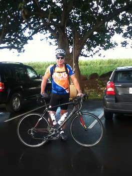
In the Paia parking lot, ready to get the show on the road.
As I leave the parking lot Shirley has already explained to some other tourists what I’m up to and I can hear them shouting “Go Garry, you can do it!” as I roll onto the street at 8:30 a.m..
The first few miles are exciting as I get used to the new bike, adjust to the roads and begin to figure out the gearing and what kind of pace I’m going to hold. It’s tempting to go hard early on with the excitement of the challenge ahead, but I’ve had some first hand advice about pacing and there is a long way to go. Already I’m taking note of the constant climbing.
From Paia it’s up Baldwin Ave. to Makawao and the first of many challenges on the ride. Just as you leave the town, there is a straight climb that jumps to a 10.4% grade for 0.4km (according to Strava). Now for a prairie rider this is a bit of a hill and while it only takes me just under 2 minutes, I’m out of the saddle and the heart is pounding by the time I crest the hill. A little easy peddling for a while on a more manageable grade and I’m good to go again.
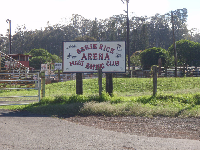
The next interesting point of the ride is a corner that everyone warns you about. Miss the turn and you can do 1,700′ of needless climbing to a dead end. In fact when we drove up on Saturday to check out the route we missed this turn even though we knew what to look for and more or less where is was. This is not to be repeated today for sure. Just to document the location, my first stop of many on the ride is to capture a few photos at 9:24 am.
Cowboy Church, I would have liked to take in a Service here!Maui Roping ClubThe Turn. If you look closely, there is a small sign for “Haleakala”
With “the turn” successfully negotiated, it’s onward and upward, ever upward, just more and more up.
The first official elevation sign
I’m still feeling quite good and enjoying looking around taking in the beautiful scenery of the uplands farming and ranching areas. At 9:44 I’ve arrived at 2500′ vertical, just a little over one hour of riding. So far, it’s just been me and a few cars, I’ve not seen any other cyclists. The road quality is good and I think I’m beginning to stabilize my pace and efforts with a heart rate holding fairly steady at 163 BPM.
Over the next few miles I see a couple of other riders going up including a couple in matching kits that I chat with for a bit. At one point a rider passes me and we greet each other briefly, and then I begin to think “I can keep pace with that guy.”. He seems to be just slightly faster that my current speed. Then I remember the advice to ride a your own pace and I suppress the competitive urge to get on his wheel. Turns out this was a really good idea. A short while later I see the same guy coming down and realize he was not going all the way to the top and could afford to expend more energy on that section of the climb.
At the intersection of 337 & Crater Road
The next stop is at about 10:18 and I snap the directional sign to the national park. While I’m stopped, the matching kit couple that I passed a while back pass me. We’ll leap-frog each other for the next few miles.
Did I mention the unrelenting nature of the climb yet? It’s really starting to test my psychological resolve. Around every corner, there is just more “up”. I think over the whole climb there are only three very brief sections, each a few hundred feet, that are flat.
The stops are getting closer and closer together. It’s not 10:42 and the legs are saying “We need a rest!”. At this corner there is a Lavender Garden display also some zipline, ATV and horseback riding services.
Lavender Garden
While I’m resting a bit the BMC rider hammers by at quite a pace. I don’t see him again.
BMC RiderHalf Way Up!
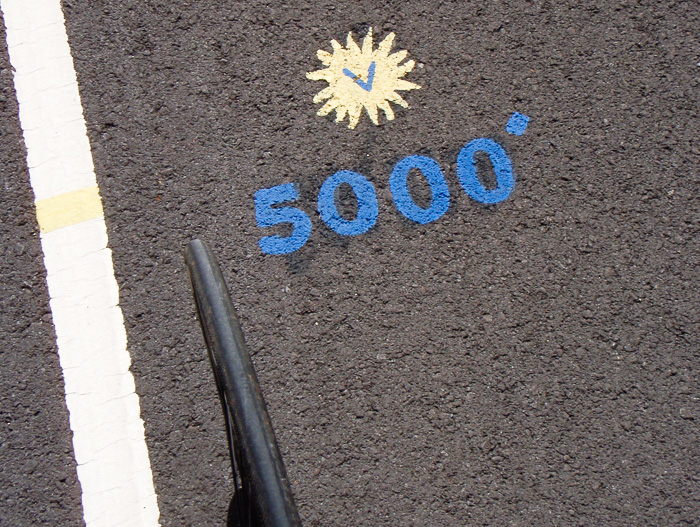
On the road outside the National Park somebody has nicely painted some signs on the road surface. Here I am at the half way point at 11:12am. In addition to elevation markers every 500′ vertical, there are encouraging reminders like “Breathe” and “Feed”. I have no problem with the breathe advice and at this point “feed” is just something I know I need to do, the desire to eat left some time ago, but I continue to force down some Power Bars.
Somewhere after 5,000′ things begin to get really tough. I’m feeling tired and I’m starting to wonder if I can really keep this up and get all the way to the top. The stops are becoming increasingly closer together and I’m starting to think about how I can explain to everyone who knows I’m doing this why I didn’t make it. The explaining seems more difficult that carrying on, so I just keep turning this cranks and setting short-term goals. In my head I’m telling myself “Keep going to that next corner”, “Another 10 minutes”, “to that sign over there”, and slowly progress is being made.
At Cloud LevelCurves and Climbing
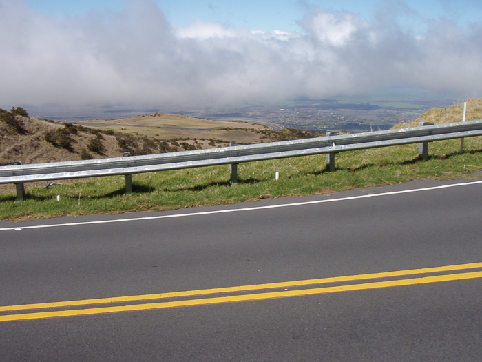
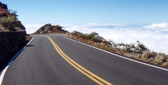
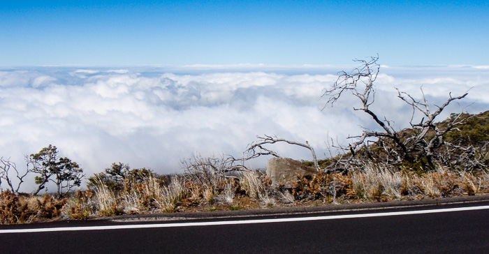
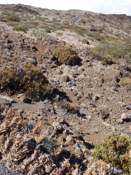
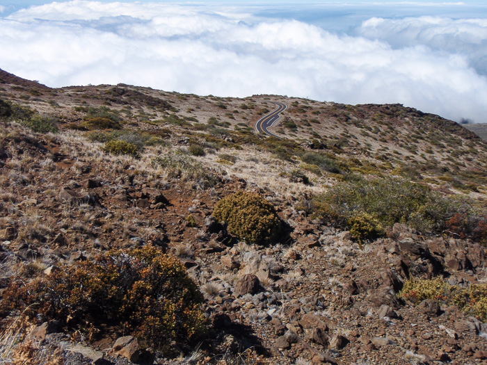
Stopped again at 11:41, good excuse to take a few more photos, which don’t do the elevation, grade or switchbacks any justice at all. This is one crazy road!. While I’m at and climbing through the cloud level, it’s not on the road and I’ve enjoyed sunshine the whole way. The temperatures have dropped significantly at this point. The refreshing coolness is nice, but the work of the climb is keeping me plenty warm with just a short sleeve jersey and shorts.
Off the bike for a few minutes.
It’s 11:55 and the legs are screaming. It’s only been 14 minutes since the last stop. This section is really difficult for me, I’m tired, losing motivation but still pressing on.
Somewhere over the next few miles I get a second wind, and the riding is getting easier. I stop on one corner under some trees for a brief rest only to find that the Park entrance was literally around the corner, where I need to stop again to show my park pass. The entrance is at about 7,000′ and I’m finding that the roads inside that park are easier to ride. There is still a good grade going up, but it seems to be more consistent where as the road outside the park had a more variable grade making for short hard sections. Either that or the altitude and exhaustion factors are kicking in and I’m hallucinating. Either way I’m feeling good and push on to 8,000′ without stopping.
Garry @ 8,000′
The Bike @ 8,000′
It’s 1:13pm and the confidence has returned, I’m going all the way to the top, and there is no stopping me now. Strangely, the riding is actually easier at this point, but there is a known hard section ahead, but no worries for now! After a good solid push, the frequent stops are returning.
The road behind
Above the CloudsThe Road Ahead
OK, I’m going to start blaming all these stops on the altitude. I’m at about 8,700′ and this stop at 1:48pm is only 14 minutes from the last one! I am going to make it all the way, right?
Lava Rock down to the RoadHigh Up & Twisty Stuff Below
Wow, an amazing push for 13 minutes before another stop at 2:01 pm, time for more photos.
Riding on the Moon
Another short-haul and the top is visible at 2:25pm! The visitor center on the left, the summit in the centre and Science City on the right. The end is near! Notice that the road conditions have deteriorated at this elevation.
Closing in on the Summit
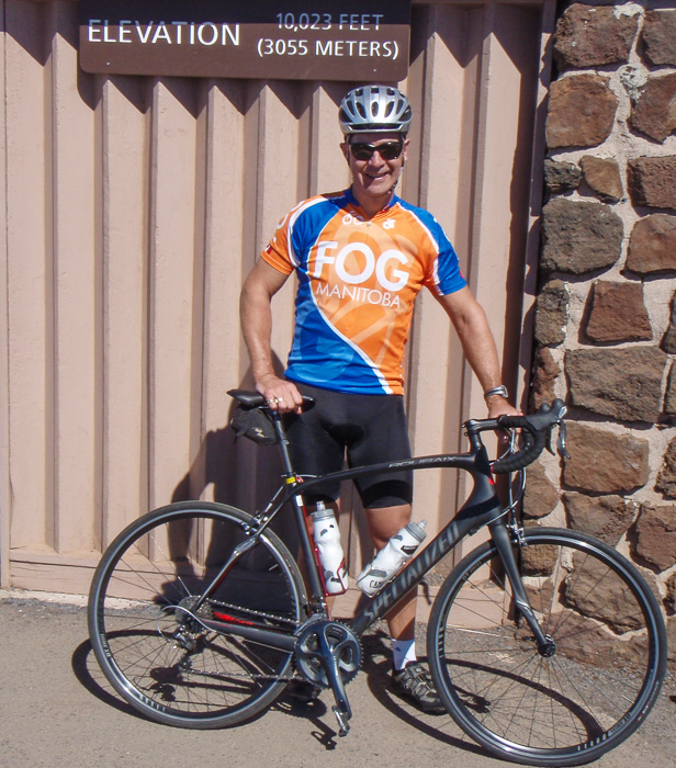
At short while later I’m at the corner that make the final turn from the visitor area to the summit. I should have stopped there for a photo, but I was feeling good and excited about the push to the top so I just motored around the corner and began what is probably the steepest section of the climb. I’ll learn later via Strava, that this segment is referred to as “The Last Brutal Effort”, and brutal it is. Despite being so close to the top, I’m forced to stop two times in this section. Getting re-started on this grade and being so tired is a challenge in itself. Then at 2:30pm, 6 hours after leaving Paia I ride across the last parking lot, up the path and top out at the summit!
Climb ConqueredOn Top of the World
At the top I met a guy from Calgary who encouraged me up the last section and took those last two photos. It felt awesome to make it to the top and I actually did a fist pump coming up the path at the end of the parking lot.
It was about 80°F at the bottom and at the summit 50°F, the predicted 30° cooler. For the ride down I’d been warned about this temperature shift. Going up and working hard in 50°F was no problem, but coasting down at up to 84km/hr was going to be a little cool, in more ways that one! After putting on leg warmers, a second long sleeve jersey, and a jacket, I’m ready for the decent, let the speed begin! BTW, no more pictures from this point on, no need to stop and having too much fun!
The first 3,000′ vertical feet literally flew by and seemingly all of a sudden I’m at the Park entrance, what a rush! The brakes really got a workout on the hairpin turns and more that a few times the rims heated up so much as to cause some brake chatter. I didn’t touch them but suspect they were smokin’ hot at some points. I’m using the full lane on the way down and at some points I’m closing up on some cars and need to back off. I’m being careful to stay on my side so as not to make a sudden discovery of a car coning up around a blind corner.
Coming up I should have taken better note of intersection where 377 joins Hanamu Road. As I get close to the turn I make a split second decision and end up turning too soon onto Kealaloa Ave. Shortly, I realize I’m going the wrong way and I’m a bit lost. To correct this mistake would mean more climbing, which at this point is out of the question. Without a map or GPS, it’s line of sight navigation. I can see the ocean and it should be all down hill so all further navigation choices are influenced by “going down” and “towards the ocean”. This results in me getting on Hwy 37, the Haleakala Highway, a very long, very straight decent. I think this is where Strava indicates I hit 84.4 km/hr! I think this might be a little fast, or at the very lease a brief spike, for sure there were some good runs at 60+ km/hr. All the speed your nerves can handle. In the end this works out, but adds somewhere between 6-8 extra miles to the ride, including 4 miles on the flat in the rain back to Paia.
It was an awesome day, a great personal accomplishment, and the climb can be summarized in one word, unrelenting.
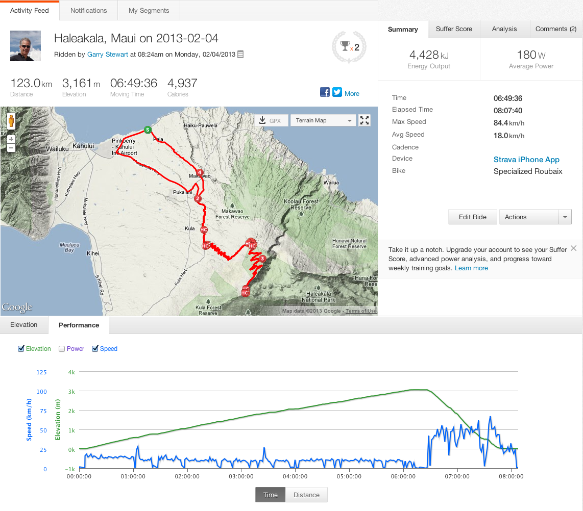
From the Strava analysis (click on picture for full size):
A lazy start to the day and breakfast at the on site restaurant , The Beach Club, gets us on the road just before noon. We’re going right past the Costco so we swing in that way for gas and unbelievably more shopping. Gas is certainly a deal at almost 25 cents below the typical gas station. However, the Saturday traffic in the area is a zoo. This little stop costs us close to 1 hr in a traffic jam.
Wave Rider at Baldwin Beach
Once free of congestion we roll over to Paia and check out a beach noted for boogie boarding and body surfing. The wind is strong and sand is blowing everywhere. This will likely be the starting point for the ride on Monday.
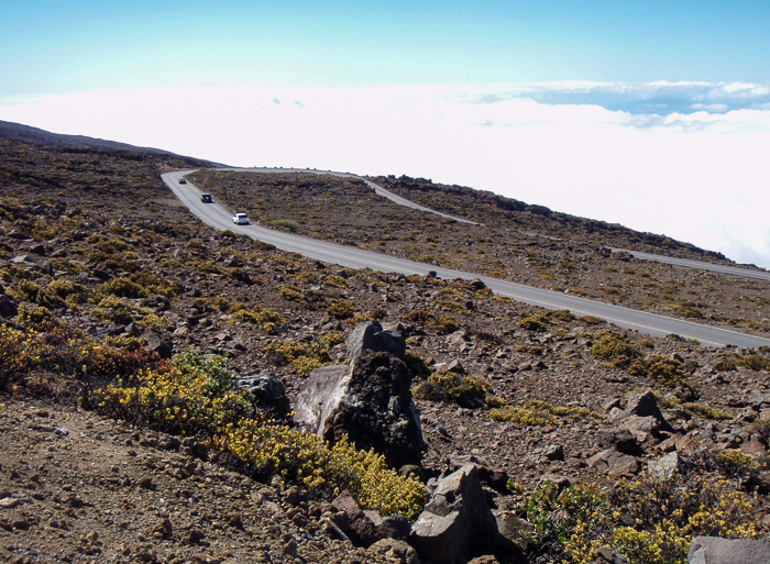
As we head up towards the summit there is one particular turn that we’ve been warned not to miss, but sure enough I blow right through the turn but quickly realize the mistake and turn around. In the car this is no big deal, on the bike it adds up to an additional 1,700′ of climbing to a dead end.
Sure enough the road is an unrelenting “up”. I note only 3 short flat sections. We see about 5 riders going up, two couples and a solo rider in a lime green jacket. I knew about the distance, the grade, the switchbacks, the narrow road in places, the 30°F temperature drop by the time you get to the top, but nobody mentioned the wind! It’s howling today and we have to brace ourselves just to walk around. At one point we spot mister lime green walking his ride. Initially I thought he was tired but later figured out that he was having trouble staying on the bike and on the road in an open section. We later saw him successfully grinding his way up to the summit. I hope it’s less windy when I ride on Monday.
As we’re driving up the scenery goes from uplands cattle grazing ranch country,
to sparse plant growth above the tree line,
and then just volcanic rock.
At Leleiwi, the first of two overlooks, we get our first glimpse of the crater. You have to hike a short distance on a trail and the wind is howling and the temperatures have dropped substantially from the 78F on the beach. Shirley returns to the car and I push on to get a look and take some pictures. I’m rewarded with a spectacular view of the crater and need to hide behind the shelter just to manage to hold steady enough to that the pictures. I intentionally increase the shutter speed just to compensate for getting buffeted around by the wind.
Leleiwi Overlook
Back in the car we continue up to the summit at Puu Ulaula Overlook (also known as Red Hill). It’s a windy walk up to the shelter but really everybody gets their picture taken under the summit sign.
It’s Windy!Shirley at the Top
At the summit you are right next to the Haleakala Obsevatory also known as Science City. Because of the US Airfoce presence here we, not alowed to go over and explore that area.
Science CityHouse of the Sun
On the way down we stop at the Visitor Center, just below the summit. It’s already closed at 2pm, (they have really short hours) so we don’t get to see the exhibits, but take quick look around and of course some more photos of the crater.
Further down the road we stop again, this time at the Kalahaku Overlook and get yet another spectacular look at the crater and surrounding areas from a different vantage point.
Crater ConesMakawao Union Church
We wind our way down the Crater Road and take a slightly different route back hoping over to Kula and then back over to Makawao where we stop to take a few pictures of this beautiful church we spotted earlier in the day.
The Makawao Union Church was built in 1916 in memorial of Henry Perrine Baldwin and is on the National Register of Historic Places. Mr. Baldwin must have been quite the force back in the day, a lot of stuff is named after him.
After checking out a couple of dinner options in Paia we decide to find a new guten-free restaurant over in Kihei which is about 45 minutes away. After picking up fish & chips we head back to the condo, another 45 minutes, and enjoy dinner and a movie. Lots exploring, lots of interesting stuff, lots of driving and we’re done for the day.